Parvamoti
Turning measurements into actionable insights at your fingertips.
Parvamoti is Basetime’s cloud platform that turns high-precision displacement data into clear, actionable insights. Measurements from your Locator devices are automatically processed, validated, and interpreted, so your team knows what’s happening, what it means, and when to act.
No manual analysis. No delays. Just reliable insight you can act on.
“Do you have the insight you need –
when it matters most?“
Monitoring projects generate vast amounts of data, but data alone doesn’t support decisions. Engineers and asset managers need to understand what is happening, whether it poses a risk, and what action is required. Without the right tools, this often depends on manual analysis, specialist expertise, and time you don’t have.
Parvamoti removes the complexity.
Parvamoti turns raw measurements from your Locator devices into clear, reliable insight into asset behavior, giving your team immediate visibility, full control, and the confidence to act without delay or dependency on third parties.
Remote access for safety, time, and cost savings
Teams can review measurement data and device status from anywhere, reducing the need for on-site visits in hazardous areas such as landslides, unstable slopes, or construction sites. Critical insights are available in near real-time, so decisions can be made quickly and safely.
Detect risks early – before they escalate
Identify millimeter-level changes and emerging trends, and respond to early warning signals before they become safety issues or costly disruptions. Large infrastructure networks are monitored with automated workflows and threshold-based alerts, so teams can focus on what matters.
Centralized monitoring management
Configure projects, manage devices, and monitor system status from a single platform – without needing to visit each monitoring location. The platform filters and presents the data that matters most, giving teams full control and oversight.
how does Parvamoti work?
How Parvamoti supports your project setup.
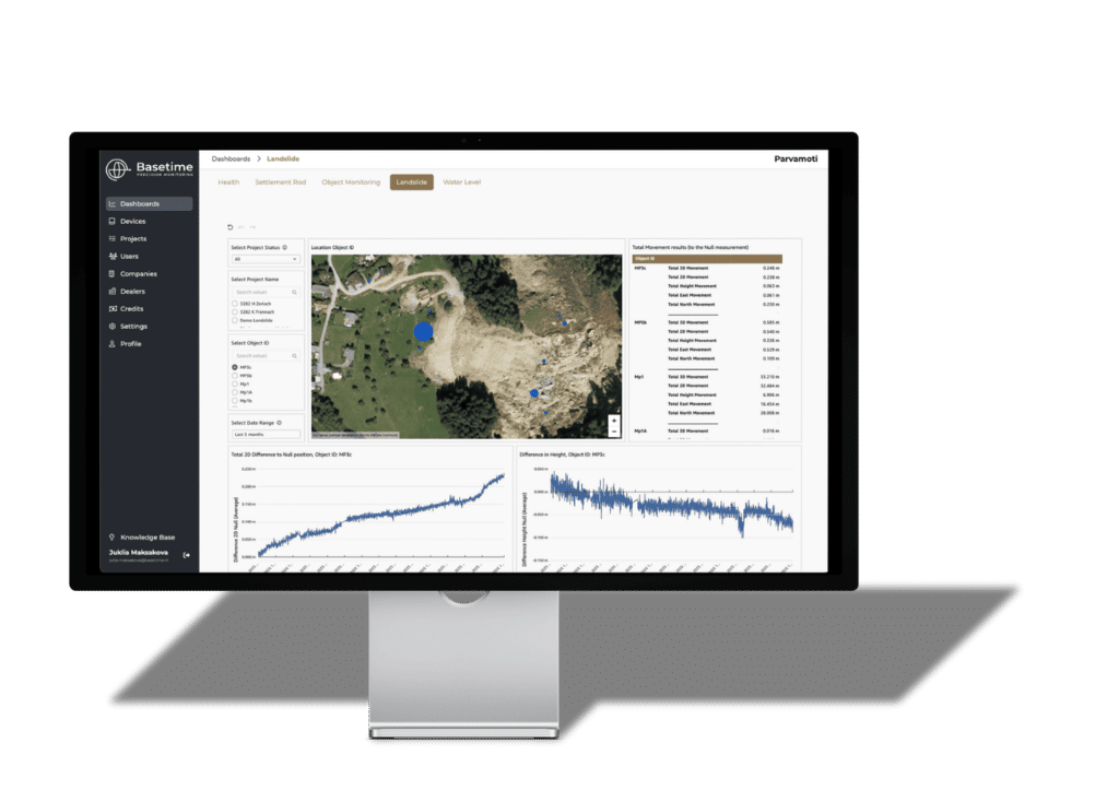
Depending on your project needs and device configuration, Locator devices collect high-precision GNSS, radar, tilt, and environmental data directly in the field. Parvamoti automatically processes, validates, and transforms this data into clear, actionable insights.
Users can analyze displacement trends, review historical data, monitor device status, and configure alerts when thresholds are exceeded. Because Parvamoti is cloud-based, all of this is accessible remotely, giving teams continuous insight into infrastructure and environmental conditions without exposing personnel to potentially dangerous situations.
Platform Capabilities
Built to adapt to your project – not the other way around.

Project Setup
Configure monitoring projects, assign devices, and define measurement intervals, so you can launch and scale faster without manual coordination.
Device Management
Ensure continuous data flow with near real-time visibility into device status, connectivity, and battery levels, without site visits.
User Management
Control access and collaboration with flexible roles and permissions, keeping your data secure and workflows structured.
Data Access, Alerts & API Integration
Turn insights into action. Configure threshold alerts, export results, or integrate directly into your asset management systems via API, so data flows where decisions are made.
“With Parvamoti, I have full control over the measurements performed with the Locator One. Configuration from my desk and instant insight into the data, this is exactly what I was waiting for!”
Ready to enhance your experience?
Ready to start your project?
Want to learn more about our solutions and how we can support your project? Contact us or request a demo.
Join Parvamoti today and revolutionize your monitoring experience. Control, insight, and efficiency, right from your desk.