The original version of the article was published in Dutch in the magazine GWW edition 06-2021 on page 164.
A range of innovative techniques are being used for the Gorinchem-Waardenburg (Netherlands) dyke improvement. One of the selected innovations is the Locator One. A Dutch development for measuring subsidence and settlement. This groundbreaking innovation combines autonomous and accurate measurement with a high predictability of the data.
As described in this special, over the next five years the dyke between Gorinchem and Waardenburg will be raised, widened and strengthened over a total length of 23 kilometers. In order to maintain control over the embankments during construction, the body of the dike is normally measured by a surveyor. As a result of the clay in the soil, this becomes a tedious and somewhat dangerous job, due to potential collision and tripping hazards. With the aim of increasing safety on the construction site and a desire for innovation, Locator One turned out to be the ideal application for the project. “We didn’t know exactly what benefits the application of Locater One would bring when the project started a year ago, but we were looking for a safer and more innovative solution. We invested in this concept together because we believed in it. Now in the realization phase, we can see what it will yield!’, says Pieter van Dueren den Hollander, project manager at Geodesie Heijmans.
Development of the Locator One
Richtlijn Geodesie and SODAQ spent three years developing the Locator One, and even set up a joint venture namely, Basetime. “The name Basetime is a combination of baseline and time, the two factors that form the basis of our reliable precision measurements,” explains Robbert Woltering of SODAQ. Basetime delivers accurate, reliable and securely collected data at any time. With this we can actually support our clients by automating geodetic monitoring and delivering data specifically tailored to the geotechnical specialist’s wishes,’ says Martijn Arkesteijn of Richtlijn Geodesie. “The Locator One devices are for sale, for rent or can be leased.”
Dyke quality assurance
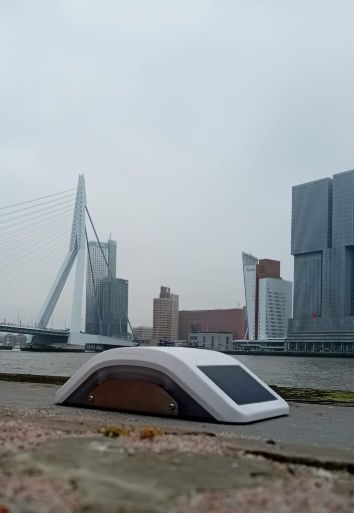
Those who are walking, cycling or driving on the Gorinchem-Waardenburg route these days, can see the Locator One. In total, 210 of these measuring devices are placed on more than 300 settlement rods. But how does the system work? Steel pipes with an exact length of two meters, with a flat steel plate (the base plate) of approximately 70 by 70 centimeters at the bottom, are placed on at ground level. The base plate is attached to a tube that is pushed into the ground, giving the whole fixture stability. This construction is called a drop level indicator and its purpose is to measure the expected settlement and change in the settlement as a result of the elevation of the dyke.
 Before the work started, various tests and CPTs were carried out on the dyke, which provided insight into the underground layers of the earth. Based on this information, the geotechnical engineer was able to perform strength calculations, with which the expected settlements and deformations were calculated. The more reliably the measurements can be performed, the better the prediction can be tested and the more certainty the client gets about the quality of the dyke.
Accuracy
A Locator One is mounted on top of the settlement beacon to automatically determine the height of the footplate and thus the original ground level. Once the system has been installed and the initial measurements have been taken, the contractor can begin applying additional soil and sand. The Locator One measures the vertical movement of the original ground level, as well as the level and thickness of the added soil layers on a daily basis. The latter is done by a calibrated radar sensor that measures the distance from the Locator One to the top of the applied sand/soil layers. The automated sensor measures the exact position of the settlement beacon with an accuracy of up to 5 millimeters in the Z-axis and 3 millimeters in the X-Y axis. The Locator One guarantees high precision and reliability. Historically 95 percent of the data collected by Locator One have led to reliable data.
Reliable Predictions
The raw data is received in the cloud. The data is then processed in the Basetime calculation environment to produce coordinates and any other information that the geotechnical department needs. Finally, the data is linked via an API to the management system of the geotechnical department, which makes it possible for the geo-technicians to analyze all information from behind their desk. Optionally, the data can also be presented via a dashboard. By combining accurate data at a predefined time, geotechnical engineers are able to provide reliable predictions of expected settlements and the period remaining until stabilization. As a result, profit can be made on the total project planning and logistics.
Safe and sustainable
In addition to accuracy and predictability, safety is a third important advantage of this innovative way of measuring. Where normally surveyors take the measurements, this is now done by the Locator One in the field. Woltering: ‘The surveyors can be deployed much more specifically for specialist activities where the knowledge and skills of the surveyor have added value. This reduces the presence of people on the construction sites. This reduction in human presence increases safety on a construction site. It has even been shown that with the use of the Locator One there are 25 times fewer movements of people on a construction site.” Arkesteijn adds: “An additional and thus fourth advantage is that by reducing the number of traffic movements you also emit less CO2. After all, the surveyor no longer has to drive to and from the various measuring locations, unless the settlement beacons have to be extended to allow them to protrude above the additional soil layers that have been applied. In addition, the Locator One is equipped with a solar cell and supercapacitor, eliminating the need for polluting batteries and contributing to a reduction of CO2 during the duration of the project. The device is also designed in such a way that it can always be repaired and does not have to be thrown away in the event of the slightest damage.”
The Locator One proves added value not only when monitoring dyke reinforcements, but also when monitoring terranean movements, in use cases such as at dredging and construction. It is used by construction companies, marine companies, geodetic and geotechnical engineers and asset managers engaged in object and soil monitoring.
Future-proof collaboration
Graaf Reinaldalliantie is committed to innovation and contributes to this goal by using the Locator One. The data is collected with the desired accuracy at the agreed time, allowing the geotechnical specialists to make a more reliable prediction of the settlement. But the biggest gains come from an increase in safety and a significant reduction in CO2 emissions on the project.
Arkesteijn and Woltering are proud that they can use their innovation. “It is a big step and we are proud of the collaboration within this project. We all have a passion for land and water and strengthen each other in this way. Together we can realize the great ambition of making all Dutch dykes future-proof.’