One for projects.
Locator One
Continuous insight into movement, deformation and settlement, throughout every stage of your project.
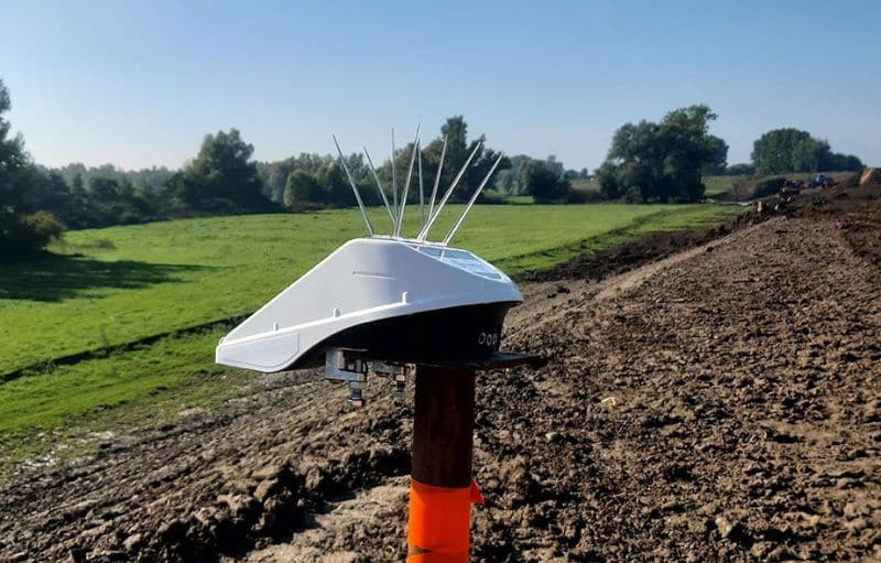
Locator One is an autonomous GNSS- and radar-based monitoring system designed for project-based applications in construction, geotechnical engineering, and infrastructure works. By combining high-precision GNSS positioning with radar distance measurements, Locator One delivers reliable 3D displacement data for monitoring settlement, movement, and water levels, helping teams stay informed and in control.
Projects move fast. Your deformation data should too.
During construction and geotechnical projects, change is constant and unexpected situations can arise. Ground conditions shift, slopes can become unstable, structures settle and loads change over time. Without continuous insight, risks can go unnoticed, and planning can become uncertain. Of course, this also provides positive insights: the absence of subsidence over the last 30 days enables more optimal planning of ground additions.
To stay in control, wouldn’t it be ideal to have reliable, automated insight into movement, deformation, and settlement throughout the project, without relying on time-consuming manual measurements?
Locator One provides autonomous monitoring that keeps you informed from the first day of installation through to the final phase of construction.
Flexible deployment and easy installation
Locator One installs quickly on settlement rods or directly on structures, enabling monitoring from the first day of installation. Whether deployed as a single unit or across a larger project area, Locator One scales easily to fit your monitoring needs.
Automated and secure monitoring
Locator One automatically transmits and processes measurements to Parvamoti, Basetime’s cloud platform, delivering validated deformation data without manual effort. All data is encrypted, giving you secure, reliable insights from day one.
Alerts when thresholds are exceeded
We're here to help your industry.
Locator One is engineered for temporary, high-precision monitoring in dynamic construction settings. Typical applications include:
Settlement Rod Monitoring
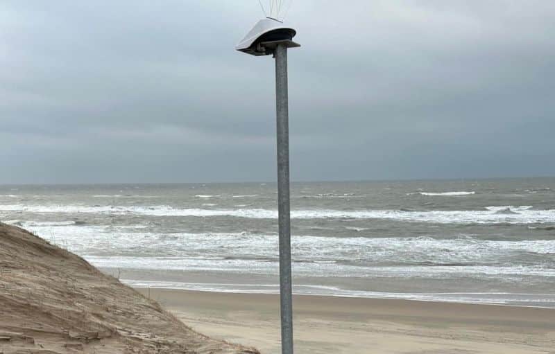
Water Level Monitoring

Ground Movement Monitoring
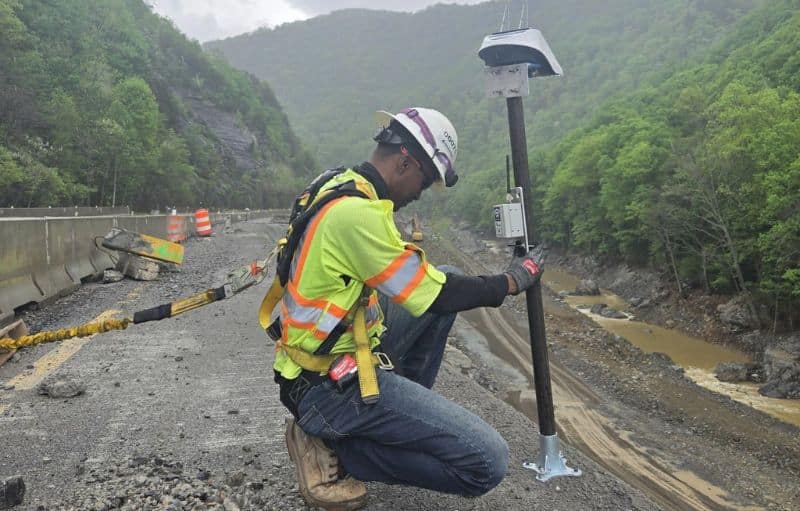
Landslide & Slope Stability Monitoring
how does locator one work?
Locator One provides your project with accurate 3D movement tracking.
Locator One is built for reliable outdoor environments and can operate autonomously using solar power. It continuously determines its position with high-precision GNSS measurements, providing accurate three-dimensional movement tracking.
An integrated radar sensor measures distances to the ground or water surface, allowing direct monitoring of settlement and water levels. All measurement data is transmitted via LTE-M to Basetime’s cloud platform, Parvamoti, where it is processed and visualized.
Users can monitor movement remotely and receive alerts whenever predefined thresholds are exceeded, ensuring consistent oversight throughout the project lifecycle.

Proven precision in the field.
Radar sensors measure distances to 1 mm, enabling simultaneous monitoring of structural movement and ground or water level changes. Built for demanding outdoor conditions, Locator One ensures reliable, high-uptime performance across projects of any scale.
All Locator One devices automatically transmit data to Parvamoti, Basetime’s cloud platform.
In Parvamoti you can:
√ Track movement
√ Configure measurements
√ View trends
√ Receive alerts
√ Export data
This allows you to monitor projects remotely and maintain oversight without frequent site visits.
Locator One Product Specifications
| General Product Specifications |
|
| Product Weight | 1547 g (excluding bird spikes) |
| Product Dimensions |
286 × 213 × 140 mm (excluding bird spikes and beam clamps) |
| Operating Conditions | –40°C to +60°C |
| Sensors | GNSS, radar, and temperature |
| Connectivity | LTE-M (bands: B1, B2, B3, B4, B5, B8, B12, B13, B14, B18, B19, B20, B25, B26, B28 and B66) |
| Power |
Supercapacitor – 4.2 V (air transport safe) Capacity – 230 GNSS measurements per full charge Solar panel – 2W PU solar panel External (optional) – USB (with custom cable) |
| Temperature | Each measurement from –40°C to +60°C |
| Casing / material |
Outside – PC-ABS white / black Beam clamps – Stainless Steel A4 |
| Mounting | Beam clamps, mounting plate and mounting bracket |
| GNSS Specifications |
|
| Constellations & bands |
GPS, GLONASS, Galileo, BeiDou, and QZSS L1C/A, L1OF, L2C, L2OF, B1I, B2I, E1B/C and E5b (186 channels) |
| Precision |
Post Processed Static (PPS): – Horizontal Precision: 2 mm + 0.5 ppm (1σ) – Vertical Precision: 4 mm + 0.5 ppm (1σ) – Long term trend-monitoring precision: <1 mm* |
| Measurement frequency |
1 to 24 times per day (without external power source in Dutch weather conditions and configurable with the Parvamoti platform)
|
| Radar Specifications | |
| Operating range |
0.40 m to 4.00 m settlement rods 0.40 m to 7.00 m water level
|
| Accuracy |
1 mm settlement rod 10 mm waterlevel
|
| Measurement frequency | 1 to 288 times per day (application dependent and configurable with the Parvamoti platform) |
| * Based on comparing daily averages of at least 12 daily measurements under similar climatic (temperature) conditions. | |
Certifications & Compliance
Locator One meets international safety and quality standards and is certified CE, FCC, UKCA, IP65, and RoHS compliant, ensuring reliable performance, safe operation, and environmental responsibility.


Get in touch
We are ready to hear from you! Leave your details here, and your industry expert will be in touch soon.