Landslide Monitoring Höbranz, Vorarlberg, Austria Case Study
Hörbranz, Vorarlberg, Austria
Project duration: November 2023 – ongoing
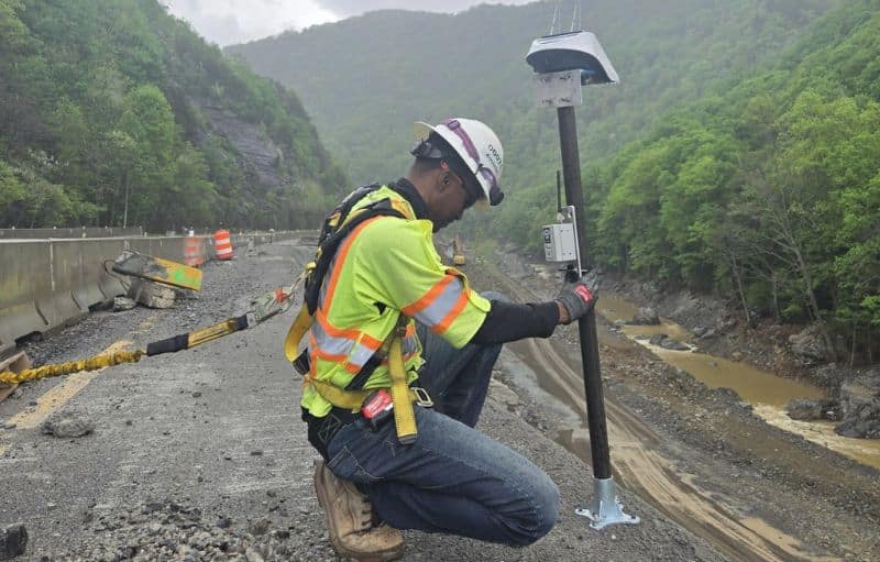
In the Austrian municipality of Hörbranz, a slope has been in continuous motion since late April 2023. The landslide has already destroyed several houses. Engineers and construction teams are working continuously, removing several tons of soil each day to stabilize the slope and prevent further damage. To actively monitor the landslide, six of Basetime’s Locator One GNSS monitoring devices were deployed at strategically selected locations to measure horizontal and vertical ground movement.
Locator one units
measurements per day
Minutes logging time
Gaining control of the landslide movements.
To actively monitor the landslide, metal rods were installed in the ground at six strategically selected locations. Each rod was equipped with Basetime’s GNSS monitoring station, Locator One, to measure horizontal and vertical ground movement. A virtual reference station (VRS) was used as the reference point for this monitoring setup.
So, how does the system work?
Continuous monitoring of slope displacement to identify risks early.
Accurate detection of acceleration phases to help prevent further damage and financial impact.
Reliable data enabling timely stabilization and safer living and working environments.
Each Locator One logs Global Navigation Satellite System (GNSS) data hourly for several minutes and sends it to Basetime’s cloud via the LTE-M network. With minimal delay, near real-time coordinates of each metal rod are calculated and displayed in the dedicated landslide dashboard within Basetime’s measurement management system, Parvamoti. This allows surveying engineers to perform calculations to assess the landslide’s impact and monitor its movement direction. The more reliable the measurements, the more accurate the predictions and the greater the client’s confidence in the data quality.
During the first few months, the landslide appeared stable, with little visible ground movement. However, by mid-February 2024, new movement began to appear. Two of the six Locator One devices registered significant shifts, which gradually accelerated over time.

Over a period of approximately 12 hours, one point experienced 1.2 meters of movement, while another shifted nearly 5 meters. Thanks to its high measurement accuracy and extensive functionality, the Locator One monitoring system has proven indispensable for effectively tracking the landslide in Hörbranz and minimizing risks to people and property.
These autonomous monitoring stations complement the existing stabilization measures, enabling a proactive response to changes in the slope’s behavior. At this stage, it is not yet possible to predict when the slope will fully stabilize.
“The Locator One gives us many insights into the movement of the landslide. It helps us monitor the environment and control the situation.”
Sub centimeter accuracy
Once the system is installed and initial measurements are taken, monitoring can begin. The Locator One records data up to 24 times per day, measuring both horizontal and vertical positions.

The Locator One determines the exact position of each settlement rod with an accuracy of up to 5 millimeters vertically and 3 millimeters horizontally. With this high precision, at least 95 percent of planned measurements provide reliable and accurate data.
Prediction and impact
Landslide forecasting plays a crucial role in ensuring safety by facilitating timely evacuation and mitigating community impacts. It also protects property and infrastructure by implementing preventive measures to minimize damage. By preparing stakeholders for potential financial impacts, landslide forecasting helps reduce economic losses associated with damages.
In summary, landslide forecasting enables communities to proactively manage risk and protect lives, property, the environment, and the economy from the damaging effects of landslides.
Other applications
Besides the monitoring of landslide in public spaces, there are also possibilities in monitoring of vital public transport assets like (rail)roads and stabilization monitoring of open pit mine slopes.
The use of monitoring systems in these contexts contributes to proactive safety measures, minimizes the risk of human injury and property damage, and enhances overall societal resilience against landslides.

Roadside Landslide Monitoring
Landslide Monitoring I-40, Asheville, USA
Get in touch
We are ready to hear from you! Leave your details here, and your industry expert will be in touch soon.